- 3D
- 3D Terrain Database File
- AddRectangle
- Adjusting Layer
- Aligning Source Files
- API Examples
- Apply
- ArcSDE Raster Server
- Attaching Polygons
- AttachToLayer
- Auto-Hide
- Borders
- Clearing Log
- Clients
- Closing Project
- Cloud Services
- Color Adjustment
- Colors Dialog Box
- Configuring TerraBuilder
- Connect
- Convert XYZ ASCII Elevation
- Convert Z ASCII Elevation
- Coordinate System
- Coordinate System Dialog Box
- Count
- Create Resolution Pyramids
- CreateMPT
- CreateResolutionPyramids
- Customized Layouts
- Cutting Polygon
- Default Ruler
- Definitions
- DetachFromLayer
- Detaching Polygons
- Different UPPs
- Directories Setting
- Disconnect
- Display Mode
- Displaying Panels
- ECW Image Web Server
- Editors
- Elevation Adjustments
- Elevation Layer Parameters
- Elevation Map
- Elevation Schemes
- Elevation Sources
- Elevation Values
- Elevation Views
- ElevationFillBehavior
- ElevationPyramidFormat
- Error/Message Log
- Excel
- ExitWhenFinished
- Exporting Polygons
- Fill Elevation
- FindPolygon
- Fit View
- Format Plug
- Frames
- Fuser
- GDAL v3
- General Tab
- GeographicHeight
- GeographicWidth
- GeoPackage Plug
- GetConnectedServer
- GetFileSystemObject
- Globe Ruler
- Globe Tab
- Google Earth Enterprise Server
- Grid
- GRW Plug
- Hardware Requirements
- HASP Driver
- Hide
- Hiding Log
- Home Tab
- I/O Issues
- Image Layer
- Image Map
- Image Quality
- Imagery
- ImageryPyramidFormat
- IMG Plug
- ImportPolygons
- Improving System Performance
- InsertLayer
- InsertLayerEx
- Language Tab
- Layout
- LeftX
- Legacy Support
- License Mechanism
- Loading SkylineGlobe Layers
- LowerY
- MakeTLT
- Manual Installation of HASP
- Mapping Shared Network Drive
- Max Elevation
- MaxVisibleUpp
- Measure Area
- Measure Distance
- Measurement Information
- Min
- MPT Creation Using Network Fusers
- MPT Generation Tab
- MPTFileName
- Name
- Navigation Commands
- New Group
- NGA Plug
- Null Values
- Opening Existing Project
- OpenProject
- Oracle Spatial Database
- Ordered Layer List View
- Output File
- Output Format
- Overlapping Files
- PixelsHeight
- PixelsWidth
- Placing Tie Points
- Polygon Edit Tab
- Polygon Operations
- Polygons Tab
- Prepare DirectConnect Project
- Preview Mode
- Project Coordinate System
- Project Information
- Project Level
- Project Ruler Tab
- Project Tree
- Project Tree View
- ProjectionGrid
- Properties Sheet
- PublishDirectConnectToSG
- PublishMPTToSG
- Pyramid File
- PyramidFileName
- PyramidIncludeSource
- PyramidPath
- Quick Access Toolbar
- RAW Plug
- Reconnect
- Reference Window
- RemoveLayer
- Renaming Group
- Reproject Tab
- ReprojectMethod
- Resume MPT Creation
- Resume Pyramid Creation
- RGB Plug
- Right-Click Menus
- RightX
- Root Area
- Ruler Setting Implications
- Save As
- Save Project
- SaveAs
- Scale Elevation
- Searching for SkylineGlobe Layers
- Security Tab
- SFLS
- SGS
- Shared Network Drive
- Shortcut Keys
- Size
- Skyline Floating License Server
- SkylineGlobe Product Suite
- Software Requirements
- Sorting Groups
- Source Extents Modifying
- Source File Types
- Source Files Aligning to Ruler
- SourcePath
- Source’s Coordinate System
- Specified Layer
- Standard Layouts
- Stopping Log
- SubSampling
- System Performance
- System Preferences
- TBGeometry70
- TBLayer70
- TBLayers70
- TBPolygon70
- TBPolygons70
- TBProject70
- TBSettings70
- TBSGServer70
- TempDirectory
- TerraBuilder70
- TerraGate
- TerraGate Server
- Tiling Files
- TLT Plug
- Tolerance
- Tools Tab
- TRI Plug
- Triangulate Irregular Elevation
- Type
- Undoing/Redoing Action
- Uninstalling TerraBuilder
- Uninstalling TerraBuilder Fusers
- Units Format
- Units Measuring
- Units Per Pixel
- UpperY
- UppInProject
- UPPX
- UPPXDeg
- UPPY
- UPPYDeg
- UseFeather
- View Tab
- Visible Range
- Web Coverage Service
- Web Map Service
- Web Map Tile Service
- Well Known Text
- WKT
Web Map Service/Web Map Tile Service
To insert a layer from a Web Map server (WMS/WMTS):
Note: TerraBuilder supports WMS versions 1.1.1 and 1.3.0, and WMTS 1.0.0.
Note: The following is the copyright information for server address: “http://maps.opengeo.org/geowebcache/service/wms?” that is pre-configured in the server addresses list: “Map data © OpenStreetMap contributors, CC-BY-SA”.
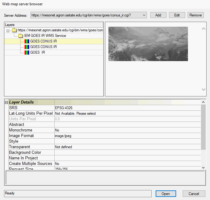
Web Map Server Browser Dialog Box
1. From the Server Address list, select a server address. If you want to modify the Address List, see “Adding, Editing, and Removing a Server Address” in this chapter.
2. In the Layers box, browse to the required data. The window on the right shows a preview of the data (when available).
3. In the Layer Details Sheet, set the properties according to the data supplier’s stipulations.
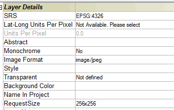
Property Sheet
Property |
Description |
SRS |
Spatial Reference System - Select the EPSG projection code indicating the projection in which the WMS/WMTS server is able to serve data. |
Lat-Long Units Per Pixel |
The best resolution level in degrees per pixel that is requested from the server. This field is only available when requesting a layer in SRS 4326 - geographic Lat-Long WGS84. |
Units Per Pixel |
The UPP of the layer. |
Abstract (read-only) |
A description of the layer. |
Monochrome |
Add the layer as a black & white source. |
Image Format |
The format of the imported layer –e.g. png or gif. |
Style |
Some layers can be displayed in more than one style (e.g. Points, Contours or Points and Contours) |
Transparent |
Select True to use WMS/WMTS layer as an overlay or False to use the WMS/WMTS layer as a base image. |
Background Color |
The layer’s background color. |
Name in Project |
The layer’s name in the Project Tree. |
Create Multiple Sources |
This property only applies when multiple WMS/WMTS layers are selected. If you select Yes, each layer is added separately as an individual layer. If you select No, all selected layers are combined and added as one layer to TB. |
Request Size |
The image size in pixels. |
Extra Parameters |
Extra parameters that are appended to any GetMap request, (e.g., Token information) for requests to a token-secured WMS service. |
Layer Names (read-only) |
The names of the selected WMS/WMTS layers. |
Style Name (read-only) |
Select the required style from the list of styles (if available). |
4. Click Open. The selected layer is added to the project and displayed in the Project Tree.
Adding, Editing, and Removing a Server Address
To add a new address:
1. Click Add. The Add Web Map Server dialog box opens.
2. Add a new address.
Note: You
can add extra parameters (e.g., Token information) to the GetMap request,
by appending the parameter at the end of the address using the following
format:
SLGetMapExtraParam={"<extra_param>"}
where <extra_param> is the extra parameter for the GetMap request.
e.g. http://www.skylineglobe.com/SFS/streamer.ashx?service=WMS&SLGetMapExtraParam={"key=12345"}
This will add key=12345 to the GetMap request.
3. Select the required service type.
4. If you want to use RESTful request encoding, select Use RESTful requests for WMTS.
Note: Some servers may require the ArcGIS compatibility check box to be selected.
Note: Some servers may require the NASG (National Administration of Surveying, Mapping and Geoinformation of China) compatibility check box to be selected (e.g., used by Tianditu).
5. Click OK.
To edit an address:
1. Select the address from the drop-down list, and click Edit. The Edit Web Map Server dialog box opens.
2. Edit the address and click OK.
To remove an address:
1. Click Remove. A message is displayed asking you to confirm the removal.
2. Click Yes to remove.